 |
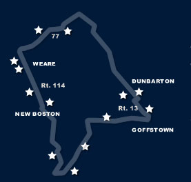
DunbartonExploring the BywayThe General John Stark Scenic Byway is a closed loop route connecting the towns of Goffstown, Dunbarton, Weare and New Boston, New Hampshire. |
Dunbarton
Originally granted as Gorham's-town in 1735, and re-granted as Starkstown in 1748, the town was incorporated in 1765 as Dunbarton. The name came from Dunbartonshire, Scotland, hometown to Archibald Stark, a prominent settler.
 The first authoritative mention of Dunbarton is from 1692, with a description of the Nipmuch Native Americans roaming the territory. Permanent settlements first appeared in 1749 when James Rogers, followed by James Putney, erected homesteads. In the mid 1700’s, John Stark was granted 100 acres of land to build a sawmill, which remained open until 1890. The presence of the Stark mill led to the construction of framed houses beginning in 1765, followed by the laying out of highways two years later. From 1752 to 1862, Dunbarton was a thriving agricultural town with dairy products regularly shipped to Boston. The production of wool, hops, wheat, flax, vegetable crops and lumber provided most families with a comfortable living.
Each year at the Dunbarton Town Meeting, in a tradition that dates back more than 245 years, residents elect hog reeves from among the couples married in the town the previous year. After being sworn in (and the ceremonial playing of a recording of a grunting swine), those elected are responsible for rounding up any loose swine and putting them in the town pound. The fine for loose swine: 25 shillings.
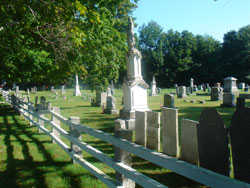
Page’s Corner Cemetery (shown above - also known as North Dunbarton Cemetery) is at the junction of Routes 13 and 77. In its northeast corner are several unmarked field stones locating the graves of the slaves who worked for Caleb Page.
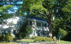 Molly Stark House (at left, not open to the public) built in 1759, was the childhood home of Elizabeth “Molly” Page who married John Stark. Their son, Caleb, was born in the house, as was Molly’s brother, Jeremiah Page who became a Superior Court Justice and delegate to the first Constitutional Convention in 1778. This house was built in two or more stages, the southern end being the oldest part. The cellar walls under the south end are laid up fieldstones in various sizes and shapes.
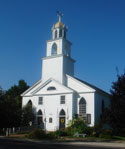 The beautifully restored 1836 meetinghouse (at left) that is the First Congregational Church of Dunbarton stands on the western side of the Dunbarton Center common. On June 18, 1789, the First Congregational Church of Dunbarton was founded with the Reverend Walter Harris as its minister. The Congregational Church members used the Town Meeting House for worship peacefully until the year 1833. Because of the increasing competition for worship space with the Baptists and Universalists, the Congregationalists decided to build a church of their own. In 1836, the Congregational Church commissioned the skills of master builder, Capt. Samuel Kimball. The Church's steeple design mimics the architecture of the steeple of the North Church of Boston. The First Congregational Church of Dunbarton worships in the historic church to this day.
Page’s Corner Schoolhouse at the junction of Routes 13 and 77 was built in 1855 from bricks manufactured at a brickyard on Gorham Pond Road. This one-room schoolhouse served as the school for the Page’s Corner area. It is now owned by the Dunbarton Historical Society and is part of their museum.
Dunbarton Center School comprisies the most westerly-situated third of the Town Office Building; this structure was originally the Dunbarton Center School. Built in 1866, it continued being used until 1972.
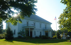 Gracing the center of the Town Common, the Dunbarton Town Hall (at left) was built in 1908. It is erected on the same site as the original 1789 Town Meetinghouse, which was destroyed by fire in 1908.
In 1791, the Town voted to build the Dunbarton Town Pound of stone to be used to contain loose livestock and pets until the owners could claim them. The dimensions of the pound were 32 feet square inside, 6 feet high of stone and a stack of timber on top with one side flat that locks the corners. The stone walls were 4 feet thick at the bottom and 3 feet thick at the top.
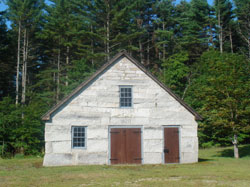 A beautiful stone structure (at left), the Waite Blacksmith Shop was built by Jonathon Waite. Originally located on the north side of Grapevine Road and built from stone cut from the Guinea Road area, it was moved stone by stone to its present day location on Stark Highway North and is now part of the Dunbarton Historical Society’s Museum.
The life-like bronze statue of Caleb Stark on the Town Common commemorates the son of John and Molly Stark, who joined his father at the Battle of Bunker Hill in Charlestown, Massachusetts.
Views to look for:
- Mt. Monadnock and Crotched Mountain, visible to the west when traveling north on Route 113. Monadnock, the most prominent New England mountain peak south of the White Mountains and east of the Massachusetts Berkshires, has long been known as one of the most frequently-climbed mountains in the world,
- Mt. Kearsarge from the top of Mill’s Hill, also visible from Route 13.
- When traveling south on NH 13, a fleeting but attractive view of Mt. Uncanoonuc can be seen to the west over the shoulder of the First Congregational Church at the center of town.
- The pine grove seen when traveling across a dam on NH 77 (Concord Stage Road) is reminiscent of the boreal forests of the north.
Turn left (west) on Route 77 to Weare.
FUNDED BY |